Energy Update



Rasuwa's Wake-UP Call: Rethinking Disaster Risk in Nepal
-
 Krishna Neupane
- 4 October, 2026
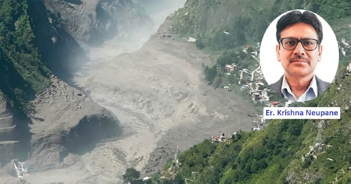
On August 26, 2026, a mountain failure in Rasuwa set off a chain of events that travelled far beyond its point of origin. A slope failure on Langtang Lirung triggered an ice-rock avalanche that entered the Bhote Koshi–Trishuli valley and moved downstream as rock, ice, water and debris. Settlements, roads, bridges, hydropower projects and other critical infrastructure were hit.
This was more than a flood.

It illustrates a risk that Nepal's fast-growing mountain infrastructure must take more seriously: a hazard that changes character as it moves through a connected landscape, triggering new hazards and disrupting the systems people depend on. A mountain failure became an avalanche, then a debris-rich flow and river surge, followed by erosion, infrastructure damage, lost access and a major emergency-response challenge.
The government's Rapid Damage and Needs Assessment has estimated damage and loss of over Rs 408 billion, while recovery and reconstruction needs around Rs 723 billion. It has identified 13 hydropower projects with a combined capacity of 759 MW and five solar projects totaling 24 MW as affected, along with extensive damage to roads and bridges.
The numbers matter. But the deeper lesson lies in how the hazard travelled.
Engineering is built around defined hazards. Flood studies consider discharge, water level, velocity and scour. Slope assessments look at stability. Structures are designed for specified loads and standards. All of this remains essential.
But a cascading event adds another dimension. An extreme mountain process can push rock and ice into a river, mobilise sediment, carry boulders and logs, block a channel or bridge, redirect the flow, and create a temporary blockage that later releases suddenly. A bridge, hydropower facility or village may then face a threat very different from what the river discharge alone would suggest.
The sequence can be stated simply as:
Mountain instability → avalanche → debris mobilization → river surge → erosion and deposition → infrastructure disruption → emergency consequences.
Each stage can worsen the next. A damaged bridge can cut off a community. A destroyed road can prevent rescuers from reaching an isolated facility. Loss of communication can delay decisions. A hydropower plant can remain structurally intact yet be unable to operate because its access road, transmission connection, or auxiliary systems have failed.
That is why cascading risk cannot be understood by looking at each hazard, or each project, separately.
Risk also changes along the river. Near the source, warning time may be extremely short and the energy of debris and boulders very high. Farther downstream, the flow becomes more water- and sediment-dominated, leaving more time to warn and evacuate. A single basin-wide assumption about risk will therefore not be adequate.
The Question: What Do We Do?
Nepal has made significant progress in hydrological monitoring, flood forecasting, disaster management, and project safety. Rasuwa is not proof that these systems do not work.
The more important question is whether hazard information reaches the decisions that create exposure: where settlements grow, where roads and bridges are placed, how hydropower projects are configured, what warning systems are required, and how emergency arrangements are organized.
Historical records remain valuable, but they cannot define the full range of Himalayan hazards. Geological, glacial and hydrological processes can interact in ways that records capture poorly. Regional assessments since Rasuwa have called for stronger multi-hazard monitoring, risk assessment and preparedness for cascading mountain hazards.
This does not mean every settlement must be relocated or every structure redesigned for every conceivable event. It means risk assessment must be tied much more closely to development decisions.
The right question is not simply whether a settlement lies inside a flood zone. Four practical questions should be asked at each location:
What type of hazard can reach it? How quickly can it arrive? Can people be warned? Can they reach safety in time?
Answering them takes more than conventional flood mapping. Depending on location, assessment may need to cover debris and boulder flow, erosion, slope instability, channel migration, temporary blockage and sudden release, and evacuation time.
The response should vary with terrain:
- High-mountain corridors and steep gorges: avoidance, safe setbacks or, where residual risk cannot reasonably be managed, relocation may be necessary.
- Other mountain valleys: controlled development, setbacks, warning systems and evacuation areas can reduce risk.
- Broader downstream valleys: where flow is more water-dominated and warning time longer, floodplain management and evacuation may offer further options.
The principle is risk-based, not uniform.
It also helps to distinguish people from property. A house cannot be made immune to every extreme event, but people can survive if warning and evacuation work. Critical infrastructure is different: it cannot be evacuated, and its failure can disrupt electricity, transport, communications, and emergency services.
Relocation should therefore be considered in locations where life-safety risk remains unacceptable after realistic mitigation, not imposed as a blanket response to living near rivers. Moving a community is never just moving houses; people depend on livelihoods, schools, markets and social networks.
An early-warning system should not be judged simply by looking at whether sensors and sirens exist. The better question is how much usable lead time remains between reliable detection and the hazard's arrival.
The warning chain is straightforward:
Detection → interpretation → warning → communication → evacuation → safe arrival.
A failure at any link weakens the whole system.
At Rasuwa, the sudden mountain origin meant communities close to the source had little or no effective warning, as alerts issued to downstream areas were more useful because of the time gap. Near the source of a sudden hazard, even a perfect alert may not give enough time to evacuate. Farther downstream, the same system can buy valuable time.
Where instruments cannot provide enough lead time, upstream observation, local knowledge and community-based communication can add layers. Warning systems must also be resilient, because disasters can damage monitoring stations, telecommunications, power supplies and roads.
Most importantly, every warning must be tied to a predetermined action: where to go, which route to use, and when to move.
So, the right question is not, "Do we have an early-warning system?" but rather how much reliable time can it give this community or facility, and what can people realistically do within that time?
A warning creates an opportunity to act. Preparedness determines whether people and institutions can use it.
A written plan is not demonstrated preparedness. A credible system needs training, simulation, working communications, equipment, and decision-making under realistic conditions:
Plan → training → simulation → evaluation → corrective action → repeat.
Nepal already recognizes mock drills and simulations as part of disaster preparedness, and the Nepal Disaster Report 2024 identified strengthening such exercises as an area needing attention.
For complex hydropower infrastructure, drills should test more than evacuation procedures.
What happens if the access road is destroyed? If communications fail? If workers are trapped underground? If the usual emergency coordinator cannot reach the site? If several facilities are hit at once?
Rasuwa also showed the importance of combining emergency command with technical knowledge. Rescuers faced difficult underground conditions and altered or buried tunnel entrances, while project engineers and technical drawings supplied information needed to locate and reach facilities.
Rescue agencies cannot be expected to know the layout of every hydropower facility, and project staff should not be expected to replace professional rescuers. The two must work together, with arrangements established before an emergency: who leads, who gives technical advice, how outside help is requested, what information rescuers need, and how alternative access and communication will be maintained.
Courage will always matter in a disaster, but resilience should not depend on heroics where a prepared system can reduce the need for them.
Rasuwa raises a basic engineering question: are our structures designed for the hazards they are likely to face, or mainly for conventional design parameters?
The answer does not require every facility to go underground or every structure to resist every conceivable event. Engineering must remain project-specific. But in steep, high-hazard corridors, location and configuration deserve as much scrutiny as structural strength.
Life safety should be built in from construction onward. Where risk assessment justifies it, underground facilities should have reliable emergency escape on safe ground independent of the main access. Tunnel portals should be protected from credible external hazards. Flood-passage systems should account for sediment, boulders, logs and ice where these are realistic threats.
Above all, design for functional survival, not merely structural survival.
A facility that is still standing but has lost its access road, bridge, transmission connection, communications or auxiliary power has not survived in any useful sense. Critical dependencies must be identified, and alternatives or redundancy be considered where consequences justify them.
This matters especially for hydropower, because each project is part of a larger network of roads, power systems, settlements and communications.
The same logic applies at the scale of the river basin. Nepal's major basins combine steep slopes, glaciers and glacial lakes, landslides, debris-prone rivers, settlements, roads, bridges, hydropower projects and transmission lines, all physically and functionally connected.
Risk assessment should follow the river, not stop at a project fence or district boundary. Authorities and developers need to know where cascading hazards can originate, how they could travel, which communities and infrastructure are exposed, and which dependencies could amplify the damage.
Warning and response need the same connectivity. Upstream information must reach downstream communities, projects and authorities through reliable channels. Where rivers cross national borders, countries must share hydrological, weather, glacier and other hazard information on time and turn it into clear information for quick action.
This does not call for identical standards everywhere. The Koshi, Gandaki and Karnali differ in geology, hydrology, settlement and infrastructure. What should be common is a risk-informed process.
The value of Rasuwa will depend on what changes afterward. Nepal should:
The aim is not another layer of bureaucracy or identical measures for every location. It is to ensure that risk information reaches decisions before exposure is created, that critical infrastructure is designed for its real hazard environment, and that institutions can act together when roads and communications fail.
Rasuwa has shown that a hazard born high in the mountains can travel through a connected river and infrastructure system. The right response is not simply to rebuild what was lost. It is to change the assumptions under which the next generation of settlements and infrastructure will be planned, designed, and operated.
Reconstruction can restore what was lost; resilience requires building differently.
[Krishna Neupane is a hydropower engineer with a Master’s degree in Water Engineering and Management from the Asian Institute of Technology (AIT), Thailand, with over 25 years of work in hydropower, water resources, infrastructure development, and sector governance. He can be reached at [email protected].]
Conversation
Krishna Neupane
Neupane is a civil engineer and gold medalist with a Master’s degree in Water Engineering and Management from the Asian Institute of Technology (AIT), Thailand.

More News




- Nepal's First Energy Based News Portal
-
Energy Information Center Pvt. Ltd.
Hemant Marg-11, Babar Mahal, Kathmandu
- Info. Dept. Reg. No. : 254/073/74
- Telephone : +977-1-5321303
- Email : [email protected]