Energy Update


Sedimentation in the Nepal Himalayas
-
 Govinda Sharma Pokharel
- 15 December, 2023
 pokharel.jpg)
Abstract
Sedimentation in the Nepal Himalayas is a complex process dependent upon numerous factors; the principal factors include geological conditions, land use pattern, mountain slope and aspect, intensity of monsoon precipitation, weathering depth, etc. Bad engineering practices in local development works exacerbate the process of mass wasting leading to sediment generation in the hills of Nepal. Similarly, climate exacerbates sediment generation and transportation by progressively increasing the intensity of rainfall in the monsoon. Sedimentation in the Nepal Himalayas is mainly supply based.

Estimation of sedimentation in the Nepalese Himalayas has been carried out by various researchers in two different ways: (a) on the basis of sediment sampling in the monsoon and their analysis and (b) on the basis of sediment deposits due to one or the other surface geological processes of the past. Both processes can complement each other, however in the Nepalese context, they have been carried out independently of each other leading to drastically varying results of mean annual sedimentation as well as mean annual denudation. Both procedures have inherent strengths and weaknesses; the weaknesses tend to exacerbate their inaccuracy.
In this context, the sediment monitoring of the Kulekhani reservoir since 1993 can fill up the gaps in sedimentation although sedimentation in large river basins is quantitatively much different from the same for smaller river basins. However, the Kulekhani data shows the actual trend of sedimentation.
As sedimentation in the Nepalese Himalayas has been dominated by peak floods caused by cloudbursts, GLOF, Landslide Dammed Lake Burst Floods (LDLBFs) with a large portion of the bed load sediments being transported in suspension together with large volumes of floating debris (which do not always float) requires to revisit the definition of sediments adding two additional categories of sediments: namely the bed load sediment that is transported by peak floods in suspension especially within the river bed scouring areas termed as intermediate category and the floating debris as the fourth category of sediments.
Because of rampant sedimentation in the Nepalese Himalayas, the river cross-section has been reduced, leading to an increase in the velocity of the flow of flood water. This has caused severe river bank cutting as well as water inundation in the neighboring fertile plains of the river valleys in both the hills and in the Terai silting, thereby degrading their agricultural quality. Because of the same reason, the rivers change course swinging back and forth. Haphazard riverbed mining adds to the flow hazards. Therefore, research on river sedimentation in the Nepal Himalayas for a better understanding of the phenomenon linked closely with the national economy vis-a-vis reservoir-type water resource management is the need of the present time.
Sedimentation of Kulekhani Reservoir
The first and the only storage-type hydropower project in Nepal, the Kulekhani-I, was conceived in the sixties and studied in the seventies. Its feasibility study report was prepared and compiled by Nippon Koei Company Ltd in 1974 . The life of the project based mainly on the sedimentation and filling of the dead storage volume was estimated between 50 and 100 years (Nippon Koei, 1983)1.
Annual mean suspended sediment load at the Kulekhani dam site for 11 years between 1963 and 1973 varied between 407 and 730 cum /year/sq km and the average for the period was calculated as 561 cum /year/sq.km. (Nippon Koei, 1983, page 4-28)1.
In the design of the Kulekhani reservoir, the bed load was considered as 15 percent of the suspended load and therefore, the total annual sediment load was calculated as 750 cum/year/sq.km (calculated as 1.15x561= 650 cum plus additional 100 cum as a sedimentation allowance for the ungauged Chakhel Khola). It had not been mentioned as any suspended or floating debris that could help fill the reservoir dead storage earlier than the estimated date. This figure of 750 cum/year/sq.km includes suspended sediment from the Chakhel tributary as the flood water from Chakhel Khola is conveyed to the Kulekhani reservoir through a two kilometer long tunnel after desilting. But as the process of desilting is not effective to the required level for suspended sediments, the catchment area of Chakhel Khola is also added to the catchment area of Kulekhani Khola in the calculation of the suspended sediments, but the bed load of Chakhel Khola is excluded in the calculation as it is excluded at the Chakhel headworks.
Therefore, annual sediment transport to the Kulekhani reservoir for a basin area of 126 sq km and 22 sq km of the Chakhel Khola basin = 148 sq km has been calculated as 111,000 cum/year. Most of the suspended sediment is expected to be deposited in the reservoir center and the downstream parts, including the areas near the dam, the intake or the bed load, whatever insignificant it was estimated, was expected to be deposited closer to the confluences of the tributaries and the foothills. The bed load tongue is expected to move from the confluence and the foothills to the interiors of the reservoir. Thus deposited bed load together with coarser suspended sediments are expected to be moving slowly towards the dam under the action of the water current.
However, the actual measurement of the sediment volume in the reservoir that started 12 years, after the reservoir was impounded, shows a totally different picture (table -1) 2,3,4 . As Kulekhani is a small catchment basin, the average for a larger basin should have been applied with a lot of caution and margin of error while determining the size of the dead storage and consequently, the life of the project during the project conception and design.
Table 1: Actual data of sedimentation measurement in Kulekhani reservoir (Any period containing one monsoon season is considered as one year)
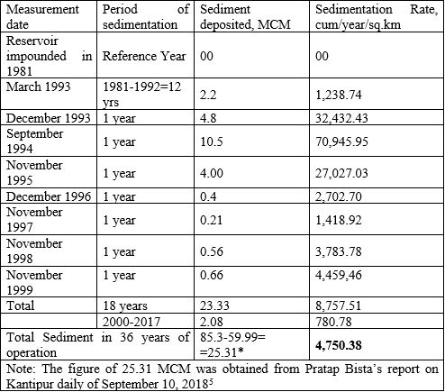
Note: The figure of 25.31 MCM was obtained from Pratap Bista’s report on Kantipur daily of September 10, 2018
The sedimentation data presented in Table 1 includes sedimentation of the reservoir since its impoundment in 1981. This information is important from the point of view that the first measurement of sediment after project completion in 1982 was made in March 1993 and that an estimated peak flood of over 360 cumecs (estimated by the author when the process of reservoir filling was in progress when the event took place) on September 30, 1981, which silted the reservoir heavily (Dhital M.R. et. al, 19936 describes a high-intensity rainfall on September 30, 1981 in the neighboring Lalitpur area but the same had been witnessed by the author on that date in Kulekhani catchment from the project camp site at Markhu). This peak flood remained unnoticed as it never reached the Bagmati where the river gauge was located and the required flood measurement facilities of the Kulekhani dam were still under construction. Therefore, its inclusion in the estimate for the total quantity of silt for 100 years is justified but its impact on the 12 year period shows an extremely high average of 1,238.74 cum/year/sq km, which should have been otherwise about half of the measured value based on the measurements between 2000 and 2017.
The above table shows that the average annual sediment transport to the Kulekhani reservoir is 4,750.38 cum/year/sq.km. This average value includes the very high sedimentation values in the post 1993 flood that was caused by the cloudburst of July 19-21, 1993, the impact of which continues for a much longer time as shown by the measurement data presented in Table 1. In statistical analyses, often, the highest and the lowest values are eliminated as outliers and the interpretation is carried out without them. But the flood of this magnitude is determined as a 100 year return period flood by the committee for case study report, 19937, therefore, it should not be ignored as an outlier. Similarly, the sedimentation due to the flood of September 30, 1981, mentioned hereinabove should be included in the calculation of annual sedimentation. The whole of the data series therefore should be treated in a fair manner so that a better average can be obtained irrespective of whether it is on the higher side or on the lower for a better estimation of sediments not only for scientific use but also for better planning of reservoirs in the Himalayas.
The sedimentation of the first 12 years of reservoir impoundment should also be treated with caution. This is because it is impacted by the abandonment of farmlands that could have been covered with crops under normal cultivation, the haphazard and unplanned relocation of displaced settlements from the reservoir to the nearby sloppy land. This involves soil excavation and dumping while its washout has it deposited in the reservoir as well as neighboring forests and shrub lands encroached by the displaced people. However, accurate estimates of the additional silt due to such activities cannot be calculated in the absence of measured data.
Therefore, considering the conclusion of the committee report that the flood of July 19-21, 1993 was a flood of 100 year return period, all the above sediment data including the ones that could have been considered outliers have been included to compute the 100-year sediment data series and hence the total volume. Hence, the volume of sediment for a return period of 100 years is calculated as presented herein below in box 1.
 This means that the Kulekhani reservoir had a life of only 32 years and that too with the front loading of the 100-year high event just after 12 years of reservoir operation as demonstrated by the actual data. However, changes in design that incorporated an additional sloping intake to allow more sediment deposition in the lake have prolonged the life of the project as a storage project. But, such an increase in project life has financial implications that may be unacceptable for some other projects.
As seen in table 1, the total sediment volume for the later 18 years until 2017 is calculated as 2.08 MCM. If total annual sediment is based on extrapolation of this number, this will certainly lead to its underestimation and any storage project designed with such number may be an ultimate failure, at least for the investor.
Therefore, for estimating the long-term average of sediments that may be carried out by a river correctly, it is important to accurately estimate the frequency of the great floods. The flood may be linked to cloud bursts in the catchment as cloud bursts can be the phenomenon that may cause all round instability of the slopes. This could result in a widespread mass wasting that may be transported first to the river bed and consequently further downstream to the sediment sampling locations and registered officially. Such cloud bursts like the one in the Bagmati catchment in 1993 can change the sediment regime of the river as it has done until at least 1993 in the case of the Kulekhani reservoir. Similarly, the inclusion of sedimentation caused by such extreme events eventually helps estimate the sedimentation more accurately as such a phenomenon is more likely to repeat with increased intensity under the action of climate change caused mainly by global warming, despite the fact that the carbon footprint of the Nepal Himalayas is very low.
1. Sediment load of Bagmati due to the 1993 flood
The report on floods in the Bagmati river basin, 19-21 July 1993 prepared and submitted by the committee in September 1993 has estimated an unprecedented peak flood in Bagmati River throughout the Bagmati Basin. The committee has estimated the peak instantaneous flood at Padheredobhan (Table 2) where the headworks for the Bagmati irrigation project is located (this location is close to the location of the proposed Nunthar dam8 by the Indian Government for flood control in Bihar). The cloudburst recorded the highest 24-hour rainfall of 540 mm in the Tistung manual gauging station located in the Kulekhani catchment on the morning of July 20, 1993.
Table 2: Peak instantaneous flood of Bagmati at Padhere Dobhan on July 20, 1993

Table 3: Historical Peak Flood Frequency Record of the Bagmati River at Padhere Dobhan (station No. 589/590) from 1965 to 1990, catchment area of 2700 sq km7, table 36, annex B
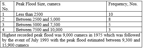
The peak instantaneous flood in 1981 was recorded as 6,120 cumecs, which is ranked seventh in the 26 year series between 1965 and 1990. But this value together with all recorded values after 1981 cannot be compared with the earlier values as they exclude flood from Kulekhani River due to dam commissioning in June 1981. The data should, therefore, be treated as two separate data series instead of one.
Efforts were made to estimate the sedimentation of the Bagmati River during the peak flood of July 1993. Various tools and methods of estimation of the sediment at Padhere Dobhan were applied however a reliable result was not obtained. Finally, it was agreed to exclude the estimate of sedimentation from the committee report however the estimation made on the basis of field observation made immediately after the event was presented separately. This amounted to about 24 to 26 percent of the total flow at Padhere Dobhan. This means that out of nearly 15,900 cumecs of peak flow, about 4,000 cumecs were the sediment including suspended sediment, bed load and floating debris. This number was somehow concluded as the peak sediment load of Bagmati at Padhere Dobhan (author). It was obvious that the sediment was dominated by partly suspended (floating) debris followed by a suspended load. However, due to an overwhelming percentage of floating debris and suspended sediments in the flow, the flood water must have been in a position to carry much larger river bed material in suspension as suspended load, which must have varied with time peaking with the peak instantaneous flood and decreasing thereafter. Therefore, any effort to distinguish between the suspended sediment and the bed load sediment during such events may raise debate, which in most cases, remains unresolved. But it was agreed during the presentation of the report that the estimate of total sediment as 25 percent was closer to the reality and thus agreed to be adopted.
2. Sedimentation and Sediment Measurement in Nepal
Sedimentation is a complex process that is dependent on local geology, mass wasting processes, a saturation of the soil or the overburden, intensity and total amount of precipitation, quality of surface runoff, weathering of the rock masses, hydrology, glacial lake outburst floods, GLOF, as well as floods due to breaching of landslide dammed lakes (LDLBF), etc., the correct evaluation of which by any means other than direct measurement is practically impossible for complex areas like the Himalayas. The collection of suspended sediment and its analysis, a simple exercise under normal circumstances is very complicated for the Himalayan rivers due to a number of reasons that include missing samples during peak instantaneous floods, changes in river profile, the accuracy of sediment sampling as well as the risk of losing the sampler itself due to floating debris in the monsoon. The accuracy of bed load estimation under such flow conditions is grossly inaccurate; more tricky is the estimation of the floating debris, which depends upon the extent and type of vegetation cover, condition of the trees in the forest and stability of land on which the forest is situated. However, the practice is to estimate the bed load as a small percentage of the total suspended sediments for a certain period of time. As sediment transportation in the Himalayan Rivers takes place predominantly in the monsoon, the sediment sampling is carried out in the monsoon and the estimates for the annual sediment load are carried out on the basis of such sampling and analysis.
In addition to the above, the sediment sampling in most of the Himalayan rivers is complicated due to the very high current at the main channel which can neither be approached nor any sample collected from there as the sampler is carried away by the current. Whatever sample is collected from the central part is collected from the surface or near-surface areas and not from areas closer to the river bed, which moves up and down due to scouring. Getting down to the river bed for sampling during the high floods is practically impossible and therefore, collection of representative suspended sediment sample, which should have included much larger sediment size in the peak floods is impossible. Therefore, the technique of sediment calculation in the Himalayan Rivers is altogether inaccurate leading to a faulty conclusion.
Sedimentation is the function of sediment yield rate and the energy of transporting agent,i.e., the river flow. Therefore, it further depends upon land use, vegetation type and coverage area, state of monsoon with two-pronged variables such as intensity and duration of rainfall as well as saturation of the erodible earth that is likely to be converted into sediments due to the action of monsoon rain. Similarly, it depends upon whether the sedimentation is taking place at the beginning of the monsoon when a large volume of loose soil (sediment) is available on the ground surface or the middle or later part of the monsoon when the ground is saturated and therefore sediment is predominantly generated by mass wasting of the saturated overburden or the weathered parent rock of the Himalayan slopes.
The actual annual sediment load for a river varies from year to year depending upon the flood hydrology, however, the mean total annual value based on long-term data is considered representative of the basin at the sample site. This is the main reason why many reservoirs get filled up much earlier than their calculated sedimentation rate in the new mountain areas like the Himalayas.
Measurement and sampling of sediments in Nepal started in 1948 from the Koshi River near Chatara for the study of the Koshi high dam project. The sampling, since then, is carried out for the suspended sediments by integration method using 500 ml sediment samplers and the analysis is carried out in the laboratory by evaporation method. Bhusal 1998 (Mool et. al., pp 21) agrees that the suspended sediment sampling of 20 locations at various sampling stations, mainly in the main rivers during the monsoon is not adequate to estimate the sediment load correctly and that the sediment yield is in direct proportion to the peak river discharge with its maximum in the month of August.
An unprecedented quantity of sediment is derived from the fragile mountain slopes of the Himalayas during the cloud bursts and whatever falls within the reach of one or the other flow channel is deposited in the river valleys. This is further transported by the high flow depositing the sediments along the river channel as the land gets flatter and the current decreases. The river enters into a new sedimentation cycle between two consecutive catastrophic meteorological events. The river delivers all that is possible for it to transport in the following years. Similarly, glacial lake outburst floods (GLOFs), Landslide Dammed Lake Bursts (LDLBFs) transport whatever comes on their way when they swell with high discharge, which may be unprecedented in the recorded history of the river and transports the deposited material as far as it can carry, depositing it further downstream. The cloud burst and/or the GLOF or LDLBFs change the sediment regime of the river and the sedimentation process enters into a new phase that transports predominantly sediments deposited by the previous catastrophic event until the next flood of similar magnitude due to GLOF, LDLBF or any other comparable meteorological event takes place. The composition of sediments in the same river basin but in different cycles may be different depending on the dominance of sediment material at the source area as well as along the flow channel of the catastrophic event. This shows that the process of sedimentation in the Himalayan Rivers is complex and any simplification of its understanding can lead to errors.
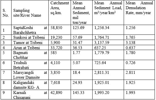
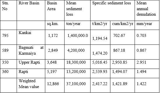
Many researchers have compiled sedimentation data on the Himalayan Rivers but many references lack the sampling location and such data create confusion. Anderman C. et al9 have compiled sediment data from various sources that include DHM, DHM/FFS and Bhote Koshi Power Company Ltd. Their findings as well as other calculated values are presented herein below in table 4 wherein the specific sediment loss and consequently the mean annual denudation rate have been calculated with a mean bulk density of 1.7 t/m3 instead of using the specific gravity of the sediment forming minerals of the suspended sediments practiced in the calculation of sediment concentration in terms of weight per unit volume.
Table 4: Sedimentation in Nepal Himalayas
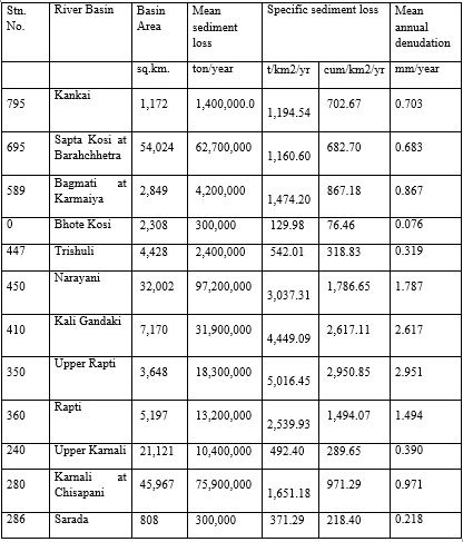
The values of specific sediment loss in cum/sq.km./year as well as mean annual denudation in the above table as calculated by this author have been found to vary from the values derived by the original authors.
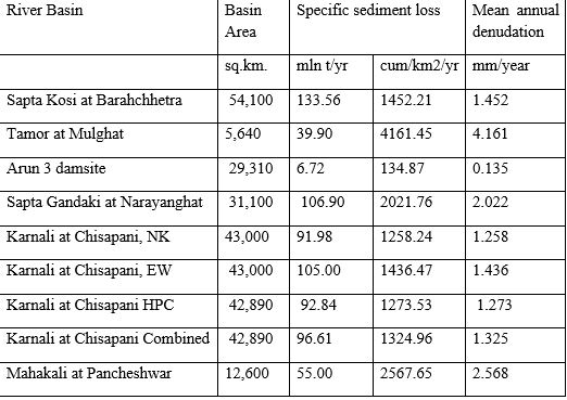
Similarly, Mool et al10 have compiled a similar table using sedimentation data from various sources. Most of the data are for a short duration of a season or so; while others are for a much longer period of time. The data have been used to calculate the mean annual denudation rate (table 5).
Table 5: Sedimentation in Nepal Himalayas
Similarly, this author has compiled information and data gathered and presented by other researchers by evaluating the sedimentation as well as denudation rates on a similar platform so that comparable values are obtained for the whole of the Himalayan hills of Nepal. The data are compiled under (Table 6):
Table 6: Sedimentation of major rivers of Nepal
Again, the above values are derived using suspended sediment data only. Therefore, the bed load content of the sediment needs to be added on top to make it complete.
In Nepal, it is a common practice to estimate the bed load as a certain small percentage of the suspended load measured for a certain period of time mostly on the basis of the published literature that represents the sum of all conditions prevailing in the basin where the data have been derived without giving any weightage to the fact on the erosion pattern in relation to its quality and quantity, which is unique in the Himalayan slopes that cannot be oversimplified. On top of the bed load sediments, the volume of floating debris in the suspended sediment, which cannot be collected in a sediment sampler plays a very important role not only in the process of sedimentation but also in the diversion of river course prevalent in the SaptaKoshi River and in other rivers of Nepal. The characteristics of a river to change its course are predominant in the higher Himalayan Rivers as also seen near the headworks of Thapa Khola hydropower project near Tukuche in Mustang district. The phenomenon is predominant where the river carrying large pieces of floating debris such as tree trunk is buried in the river bed across the river flow into a loosely cemented and less compacted soil of great lateral spread forcing the river to follow the tree trunk or large branch thus diverting the river flow altogether. This is why the behavior of Koshi and Gandak are so different from one another in India where Koshi is well known for its change in course whereas Gandak predominantly flows through the same channel.
Therefore, the values of total sediment flow in the gauging stations included in the above tables must be higher than the presently estimated values if all the sediments are duly considered and properly revised to reflect the actual situation of sedimentation in the Himalayan Rivers of Nepal. On top, due weightage in the estimation of sediments should be given to the sedimentation during the annual as well as unprecedented peak instantaneous floods that often change the sediment regime of the river course. This is very important for the Himalayan Rivers characterized by frequent peak floods from cloud bursts as well as from GLOF not only in Nepal but also in neighboring Tibet that impacts the sedimentation regime in Nepal10 , p12.
An attempt has been made herein to compile all available data on sedimentation as presented hereinabove. But, I would like to draw attention to some important facts about some intermediate conclusions concerning sediments in the Nepalese Himalayas. The first one is the fact related to the comparison of sedimentation values in the Tamor basin pre and post-GLOF of June 198011 . The values have been presented as under (table 7)10 p23.
Table 7: Sedimentation values of Tamor at Mulghat
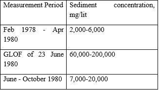 These values of sedimentation correlate well with the sedimentation of the Kulekhani reservoir pre and post 1993 cloudburst as presented hereinabove in Table 1 and box 1. Similarly, this author’s estimates of peak sediment load of about 25 percent of the total flow during the peak flood at Padheredobhan in 1993 cloudburst correlates with the estimated peak sediment concentration of Tamor GLOF of June 1980.
The sedimentation data of Arun at Tribeni, Trishuli at Betrabati (Table 6) and SaptaKosi at Barahchhetra (Table 4) show the impact of low sediment yielding Tibetan region characterised by mean annual sediment yield of about 92 ton/sq.km.12 in the mean annual sedimentation values. With correction, the values of mean annual sediment yield of Arun, Sunkosi and Trishuli basins within Nepal are calculated as 2,389.42, 1,960.68 and 2,135.53 cum/sq.km./year, respectively. Therefore, the calculated weighted average for the SaptaKoshi basin at Barahchhetra has been calculated as 2101.42 cum/sq.km./year. Similar weighted average of mean annual sediment yield for the Narayani basin at Betrabati has been calculated on the basis of the above three values as 2,213.54 cum/sq.km./year. But the sedimentation values estimated for the Narayani River at Narayanghat as per tables 4 and 5 show different values. Therefore, a further calculation of weighted value of mean annual sedimentation of the Narayani basin at Narayanghat in Nepal has been found to be 2,278.59 cum/sq.km./year. In the same way, the mean annual sediment yield of the Nepalese part of the Karnali River at Chisapani is calculated as 1,519.36 cum/sq.km./year.
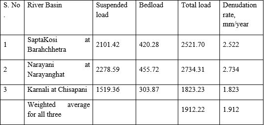
But as the sedimentation figures presented hereinabove are values for the suspended sediments only and that due consideration for the bed load and floating debris especially during the peak floods is required to be made for a better estimation of sedimentation especially reservoir sedimentation, which has high economic as well as political implications. Considering high erosion as well as mass wasting rates of the Nepalese Himalayas on a longer term, the value of bed load as 20 percent of the total suspended sediment load looks reasonable. Therefore, the specific sediment yields (in cum/sq km/year) of the main three first order river basins of Nepal including bed load of 20 percent has been tabulated as under (Table 8):
Table 8: Specific sediment yields of the first order river basins including bedload
3. Difficulties in Sediment Sampling in Nepal
As mentioned hereinabove, the sediment sampling in Nepal was started from Chatara, near Barahchhetra for the study of Kosi high dam in 1948. Gauging and sediment sampling in the Karnali River near Chisapani should be the next in line starting in 1964. The study of hydrology and sedimentology in Mahakali River must have been the first such exercise which should have started in around 1920 by the British but as the data are not available in the public domain, they are of no use for this study. Similar is the case with the Gandak River data collected in India.
A number of rivers have been gauged in the last 50 years or so but sediment data are still scarcely available. In addition, a large number of rivers have been gauged by the independent power producers as the private hydropower developers known in Nepal (IPPs) since 1992 but most of them follow neither standard sampling procedures nor they continue sampling after the project is approved by the competent authority for construction. All this shows that the importance of river sedimentation has not been understood properly either by government agencies or by the private sector in Nepal.
But there are difficulties in getting quality data on sediments in the Himalayan Rivers as they are associated with great complexities and risks as discussed in the following paragraphs:
Access to sediment sampling site: Himalayan Rivers in Nepal carry almost 75 percent of its flow as well as practically 100 percent of sediments in the monsoon for four months. Therefore, sediment sampling is being carried out during the monsoon months only. But the first hurdle in sediment sampling is provided by the remote location of the Himalayan Rivers with poor accessibility as well as great risk of all possible mountain hazards that can take place in the monsoon. Because of this, the business of sediment sampling is generally entrusted to some local residents with limited training on sediment sampling without any possibility of direct or indirect supervision required for a quality sampling procedure.
Missing peak floods with peak sedimentation fluxes: The sediment sampling in Nepal is generally carried out on a daily basis at a certain hour of the day and one will certainly miss all the peak floods with the highest sediment concentration occurring at other hours leading to missing the peak floods and consequently leading to under-estimation of suspended sediments13.
Access to sediment sampling depth of the river: Sediment sampling is generally carried out through a steel cage hung on a steel cable stretched across the river with a measured cross section from where the sediment sampling is to be carried out. A 500ml standard brass sediment sampler is lowered from the steel cage towards the point in the river from where the sediment sampling is to be carried out but the sampler is carried away downstream by the high current of the flooding river ruling out any possibility of sediment sampling from the pre-measured cross- section of the river but much downstream of it. Because of the high water current, the sampler may never reach the depth from where the sample is to be collected and whatever sample is collected may not represent the sample of the design.
Another difficulty lies in the fact that the river cross-section is surveyed in the low flow season when the river hardly carries any sediment and that the sediment sampling is carried out in the monsoon when the river is loaded with sediments. But, due to the high velocity of river flow in the monsoon, the riverbed is scoured with substantial changes in river profile that can have a substantial deviation in sediment measurement and analysis as it is likely to involve larger particle size in suspension at the desired sampling depth. This may also require a revision of the definition of sediment for the Himalayan rivers as some particle size under normal flow behaves as bed load but the same size behaves as a suspended load during high floods including the peak floods. Therefore, the Himalayan Rivers can have 4 categories of river sediments: bed load sediments, suspended sediments and the proposed new one in between them as provisionally suspended sediments. In addition, floating debris can be considered as the fourth category of sediments; such debris normally floats but not always as it is often buried by the high river current and turbulence, especially in the mountain environment. These last two categories of sediments cannot be normally sampled but can have significant importance in river management as well as in flood water management. Similarly, the floating debris hardly floats during the GLOF and LDLBFs especially when it forms the front tongue.
In addition, the process of sediment sampling in Nepal in the monsoon is associated with the risk of losing the sediment sampler due to being buried or stuck in bed load or being washed out due to the impact of high current and the floating debris. Therefore, a practical solution for sediment sampling in Nepal has been adopted which involves the collection of sediment samples with a bucket from near the river bank. This method of sediment sampling is not accurate but still practiced for the design of run-of-river hydropower projects with no storage of water behind the dam.
4. Sedimentation Assessment from Denudation
Large numbers of references are available on the topic of sediment generation in the Nepal Himalayas but most of the references have been the results of a few years of research in any particular areas covering one river basin or the other. But what is lacking in this field is a data set for a long period of time as short data sets can have a high chance of missing one or the other catastrophic event though its history can fairly accurately be reconstructed later on. Mean annual erosion rates calculated from suspended sediment fluxes have been found to range from 0.1 to 2.8 mm/yr in Nepal Himalayas. The erosion rates of the three first-order river basins of Nepal vary in the range of 0.9–1.5 mm/yr. But, erosion rates in Nepal Himalayas vary from one physiographical region to another. It is found that the erosion rates in the Higher Himalayas are relatively low (≤0.5 mm/yr, except for Kali Gandaki) compared to the Lesser Himalayas where they have been found to range from 0.2 to 2 mm/yr9. It is clear from the studies that the sediment-forming material transported by the rivers, in the first place, depends on the sediment supply from the hill slopes, which is dependent upon the runoff produced by heavy rainfall. It is also observed that the erosion processes are more controlled by moderate events of precipitation compared with the few catastrophic ones though the catastrophic events define the beginning and the end of any sedimentation cycle in the Himalayas. The conclusions of some of the prominent researchers have been discussed in brief in the following paragraphs.
Andermann et al. (2012) estimated the suspended sediment denudation rate of the Kali Gandaki river basin to be as high as up to 2.8 mm/yr, the highest among the major drainage systems of Nepal. What is very interesting is the fact that the upper catchments of the Kaligandaki basin characterised by very low annual precipitation and very high persistent winds have been diagnosed to denude most compared to much wetter middle and lower catchment areas. Fort M., and Cossart E., 201314 conclude that the landslides and other processes of mass wasting contribute to most of the sediment generation in the Kali Gandaki valley.
Maarten L., et.al, have found that the individual Himalayan-catchment denudation rates range from 0.5 to 2.4 mm per year15 with the higher rate for the Karnali River at Chisapani. The denudation rate for Karnali at the main boundary thrust, MBT is calculated as 0.6 mm/year whereas the same for Chisapani has been calculated as 2.4 mm/year which is much higher than the denudation rates concluded hereinabove in Table 8. Similarly, the denudation rates for the Narayani River near Narayanghat have been determined to vary from 1.3 to 2.1 mm per year. Similarly, denudation rates for the Koshi River at Chatara have been found to vary between 0.5 and 1.0 mm per year which has been concluded to be much higher hereinabove (table 8). Sharma C. K. has derived the mean annual sediment load of Sapta Koshi at Chatara as 97 MCM/year16, which after correction for the low sediment-yielding Tibetan region results in the mean annual sediment yield for the Nepal’s section of the basin as 3,000 cum/sq km/year.
Similarly, Clift et.al concludes that regional erosion rates in the western Himalayas are controlled by the rainfall intensity of the monsoon. Monsoon rains appear to be the primary force controlling erosion across the western Himalayas, at least over millennial time scales17.
Burbank D. W., et.al., based on a suspended-to-bedload ratio of 2:1 (as estimated from grain sizes in a landslide-dammed paleo-lake), concluded that the erosion rates range from 0.1 mm/yr in the northern rain shadow areas to about 2 mm/year in the monsoon drenched southern slopes. This strong variation in spatial erosion rates can be correlated with the precipitation across the same area and broadly correlates with specific discharge18.
Gabet J. E. et.al., on the basis of research carried out for a period of 2 to 5 years through 10 river monitoring stations in the Marsyangdi valley in the Gandaki river basin, have found that the mean annual denudation rate in the various river sub-basins varied from a low of 0.1 mm/year to a high of 2mm/year19. They also concluded that the mean annual denudation rates of the wetter south-facing slopes are much higher than the less precipitating as well as more stable north- facing slopes.
Fort M has determined that the mean annual denudation rates of various river basins of Nepal Himalayas range from a low of 0.1 mm/year to as high as 2 mm/year with exceptionally high denudation rates of up to 33 mm/year for Langtang area20. Similarly, the most important from the view point of sediment generation is the conclusion that the sediments are generated more through the processes of mass wasting and not so much through any other erosion type that includes erosion from cultivated areas21.
Mishra K, et al22 has tried to analyse the sediment connectivity in the Koshi Basin of Nepal which has classified the basin and its constituent sub-basins as highly connected, moderately connected and lowly connected between the sediment source areas and the sedimentation (receiving) areas. However, the precipitation and river flow data presented therein seem to need revisiting.
West A. J. et al, on the basis of their research on denudation and sediment yield have come to the conclusion that the mean annual soil loss rate or sediment flux rate is not uniform and that it varies from one geographical region of the Himalayas to another. Typical rates have been tabulated, which have been found to vary from a low of 0.11 mm/year to 2-3mm/year for the Khudi river sub-basin of the Marsyangdi river basin. Similarly, the sedimentation rate for the whole of the Trishuli river basin has been found to be varying between 542 and 970 tons/sq km/year equivalent to the denudation rate of 0.21 to 0.37 mm/year23.
Carson B. 19855, table 3, page 24 has adopted the estimated denudation rates for 3 main tributaries of the SaptaKoshi River from Williams 1977 as cited (as Williams V. 1977. Neotectonic implications of the alluvial record in the SaptaKoshi drainage basin, Nepalese Himalaya, University of Washington, Ph.D.) and calculated the denudation rate for the Saptakoshi basin at Barahchhetra (as quoted hereinbelow) in table 9.
Table 9: Denudation rates of Sapta Koshi basin
 The mean annual denudation rate for the Sapta Koshi basin has been calculated as about 1mm per year, but the rates quoted by different references vary from each other. However, the denudation rate from any source other than the ones based on the dislocated volumes including the ones based on the analysis of suspended sediments needs to be corrected as the figures based on the analysis of suspended sediments use the specific gravity of the sediment as something varying between 2.6 and 2.72 but as the sediments are deposited on the ground where their bulk specific gravity varies between 1.5 and 1.8. Therefore, it is advised to increase the bulk volume of the sediment by multiplying the obtained values by a factor of, say 1.6.
In addition to that the figures of denudation rates are for the entire basin and they need to be corrected for their application as denudation rates of Nepal Himalayas considering their basin area in a low-yielding Tibetan region of China. With the correction measures given, the above table can be revised as in Table 10.
Table 10: Revised denudation rates of Nepal Himalaya

The sedimentation of river basins of the Nepal Himalayas has been found to be highly supply based as concluded by the study conducted by Electrowatt Engineering Services Limited in 1982 (WECS 1987)3 page 25 in Tamor river at Mulghat. The study clearly shows the impact of GLOF on sedimentation. Similar is the conclusion of sediment analysis of the Kulekhani reservoir after the catastrophic cloud burst of 1993 as discussed hereinabove.
Based on the discussions presented hereinabove, the long-term mean annual denudation rates of various river basins of the Nepal Himalayas have been concluded to vary between a low of about 0.1 mm/year for the north-facing stable slopes of predominantly high Himalayan valleys to a high of 2.8 mm/year for monsoon drenched south-facing slopes of the lesser Himalaya and the Siwaliks. Therefore, in principle, the mean annual denudation rate for any location depends upon the percentage of the two main physiographic zones through which the first-order rivers flow. For the second-order river basins, the estimated mean annual denudation rates can be higher than the values for monsoon-drenched south-facing slopes of the lesser Himalayas and the Siwaliks however they have been determined to be less than the figures for the south-facing slopes of the lesser Himalaya and the Siwaliks (Table 4); the same for the second-order rivers of Nepal has been summarized hereinbelow in Table 11.
Table 11: Denudation rates of second order rivers of Nepal
The lower values of mean annual denudation rates of the second-order river basins of Nepal as presented in the above table could have been caused by the difficulties of sediment sampling as discussed earlier, as well as the high possibility of missing peak floods with the highest possible sediment concentration in the sample. This may also have been caused because of a shorter duration of gauging and sampling in these rivers.
5. Sedimentation in the neighborhood
Nepal and the northern hills of India share similar Himalayan geology, environment and monsoon though the eastern hills and the western hills of India are quite different in terms of mean annual rainfall and mean monsoon rainfall. River gauging in India started much earlier by the British than in Nepal. Therefore, the data from the Indian Himalayan rivers could help understand the river flow and sediment generation, transportation and deposition in the Himalayan valleys. But Indian data are not available in the public domain, therefore, cannot be relied upon. However, efforts have been made by South Asia Network on Dams, Rivers and People (SANDRP) to publish a paper in 2006, which shows that the sedimentation rate in the Indian reservoirs is very high24. But, as the basin area of the reservoir is not mentioned in the publication, nothing about the specific sedimentation rate can be concluded from it and hence comparison between the basins is not possible.
The sedimentation by suspended sediments several Himalayan countries in the neighborhood has been summarized to vary between 700 and 10,000 t/sq.km/year, with the values for Nepal varying between 1000 and 5000 t/sq.km/year25. These values obviously contain errors caused by a poor estimation of bed load, sediment sampling in extreme floods, and the impacts of floating debris on total sediment volumes.
6. Sedimentation in the Terai by the third and the fourth-order rivers
The second-order rivers are the ones that originate in the mid-hills and are predominantly spring-fed in the non-monsoon period. In the monsoon, all rivers of Nepal are predominantly rainfed. There are many rivers that originate at the mid-hills, but only a few, such as Kankai, Kamala, Bagmati, West Rapti and Babai, have been recognized as second-order rivers; others are treated as lower-order rivers. It is mainly due to the fact that they have a relatively insignificant flow during the dry lean period. Such second-order rivers that hardly get any attention in the media include Biring, Lohandra, Letang, Sardu, Sunsari, Triyuga, Lal Bakaiya, East Rapti, Manahari, Lothar, Tinau, Banganga, etc though their importance as a source of local water supply and irrigation cannot be minimized.
The third-order rivers originate in the Siwaliks and the fourth-order rivers originate at the Bhabar or at the Terai itself. The sedimentation by the rivers that originate at the Terai is limited as the water current is small and therefore the erosion is less significant compared to rivers that originate in the Bhabar and the Siwaliks or the higher-order rivers although most of the Terai is composed of loose or loosely cemented soil. The sedimentation by the lower order rivers in Terai is less significant also because the sediment generated in the Terai is transported downstream and deposited often across the border and is not noticed in Nepal Terai, where the sediments generated in the upstream areas that include the Siwalik Hills and the Bhabar zones dominate.
The sedimentation due to the second and the lower-order rivers is widespread. There is a general dominance of erosion in the second-order rivers in Nepal, whereas the third-order rivers transport a colossal amount of sediment derived from the Siwaliks and the Bhabar zones, where the process of sediment generation has been rampant in the last few decades due to haphazard deforestation and bad engineering practices that also includes rampant and indiscriminate riverbed mining often extending outside the river boundary. Widespread deposition of sediments on the rice fields along the Bagmati valley in the Terai was witnessed during the flooding of 1993. The sedimentation by the higher order rivers in Nepal is generally limited to their valleys in the hills and the mountains, however the sedimentation in the Terai covers all neighboring rice fields deteriorating their productivity and adversely affecting the national economy.
The sediments generated in the Siwaliks and the Bhabar areas of Nepal are transported by the gushing rivers in the monsoon and deposited as the rivers enter the Terai, where the river current decreases with the decrease in the general river gradient. The suspended particles are however segregated and carried over a longer distance before they are settled either in the riverbed or in the neighboring rice field, whatever the case may be. But, the deposition of mostly ungraded bed load sediment with organic debris causes a rapid rise of the riverbed, decreasing the water-containing capacity of the river channel and leading to flooding of the neighboring rice fields. Often the stagnant water remains for a much longer period, even after the floods recede.
Therefore, the core of the problem lies in the fact that the river cross-section is being filled up by the sediments and by organic debris transported and deposited by the rivers, mostly lower-order Rivers, in case of Terai. This requires the river sedimentation to be monitored individually, suitable plans prepared for their dredging and implemented so that the river cross-section or the space required for the flood water to flow is available in the river itself with no significant increase in the flow velocity and over-topping of the river banks by the flooding rivers. The stories of sedimentation by the lower-order rivers in Nepal are limited to qualitative descriptions only, though some of the leading farmers have records of river beds rising in their neighborhoods. Such data cannot be used in the absence of properly designed research on the subject.
Despite the above reality, no sediment sampling and analysis is being carried out in these rivers, therefore the sedimentation data of the gauging stations in India are required for any meaningful calculation and analysis.
7. Conclusions
Sedimentation of the Nepalese Himalaya is a complex process because of its unique and fragile geology, changing land use, high-intensity precipitation during the monsoon and vegetation cover that ranges from tropical broad-leaved to alpine coniferous forest with all varieties in between the above extremes. The process of sediment sampling and analysis based mainly on international literature and practices faces many challenges in the remote Himalayan river valleys that include the impossibility of collecting sediment samples from the desired point because of extreme and varying riverbed scouring and disturbances caused by high water current, floating debris and changing the grain size of the suspended sediments. On the other hand, an estimation of sedimentation, as well as land denudation based on the reconstruction of historical mass wasting and other severe erosional processes, has its own difficulties that determine the accuracy of the research. In addition, comparing the above two methods to conclude about mean annual sedimentation and main annual denudation rates is challenging as the values from these methods often contradict each other and taking an arithmetic mean seems to be the most undesired solution. However, qualitatively, it is clear from above that the sedimentation in the north-facing Himalayan slopes, including the Tibetan region of China, is the lowest; the values of mean annual sedimentation increase from north to south.
Estimation of bed load based on the suspended sediment load for the Nepalese Himalayan Rivers provides oversimplification of the rather complex process that is certainly likely to lead to erroneous conclusions. But, the estimate of bed load as 15% of the suspended load needs an immediate revision. The most difficult part is to define and recognize to use the intermediate category of sediment that behaves as suspended sediment during high floods but remains a bed load under normal flooding situations. The other difficulty is associated with floating debris, the fourth category of sediments in the Nepalese Himalayas, which normally floats unless such debris forms the front of the GLOF or LDLBF when they are buried under sediments because of extreme turbulence.
It is understood that the sedimentation in the Nepalese Himalayas is supply based, which varies from the beginning of the monsoon when dry soil is available in plenty on the Himalayan slopes for their transport to sediments derived from mass wasting in the monsoon-drenched saturated slopes. Mountain hazards caused by occasional cloudbursts make the supply side of sediments easier for the monsoon floods to carry. GLOF and LDLBF do the rest by transporting whatever comes on their way, depositing the load gradually as the gradient decreases; the river transports such material in the subsequent years.
Extreme events such as great floods, GLOF, and LDLBF generate extreme sedimentation; such values of sedimentation are normally ignored during statistical analysis as outliers, but such outliers actually define the sedimentation cycle and the beginning and the end of a cycle. Often, such extreme events cause changes in the availability of one or the other sediment-forming material and therefore, the mineralogical contents of sediments from one cycle may differ from the same for another cycle for the same river basin. Therefore, mixing sediment data on two sides of a catastrophic event can lead to errors.
Riverbed sedimentation provides construction materials in the river; similar processes have created fertile terraced alluvial fans along the major Himalayan river basins. But this situation has changed because of the concentration of towns and cities along the river. Therefore, the safety of people and their properties is the major concern of the day. Construction material available in the riverbed is being mined everywhere in the hills and the plains of Nepal. But riverbed mining is causing more concern than solace: haphazardly and indiscriminate riverbed mining should be replaced by well-planned activity for the maximization of benefits, to conserve riverine ecology and river cross-section both in the hills and the plains.
Special programs to study and research riverbed sedimentation involving university students as well as professors are urgently required to correctly understand the phenomenon that is different for different river basins; the special focus should be given to sedimentation as the rivers emerge from the hills to the plains and along the main rivers in Terai. This should lead to the formulation of effective plans and programs for riverbed mining in the Terai region of Nepal where siltation is closely associated with flooding and siltation on the fertile paddy fields along the river course, rampant bank cutting by the flooding rivers and an overall deterioration in the economic and social well-being of the local communities impacting adversely the national economy.
References (Citation)
1, Nippon Koei Company Limited, Tokyo, 1983, Project Completion Report of Kulekhani Hydroelectric Project, HMG, Kulekhani Hydroelectric Development Board
2, Paudel A.,2001, Dissertation in partial fulfillment of the requirements for the Masters’ degree in Geology, Sedimentation in the Kulekhani Nepal Electricity Authority, NEA, 1995, Report on Sedimentation Survey of Kulekhani Reservoir, Investigation Department, NEA
3, HMG/Ministry of Forest and Soil Conservation, Department of Soil Conservation, March 1994, Siltation Survey of Kulekhani Reservoir, December 1993
4, Nepal Electricity Authority, NEA, 2000, Report on Kulekhani Reservoir Sedimentation Study, Soil Rock and Concrete Laboratory, SRCL, NEA
5, Pratap Bista, 2018, Report in Kantipur daily on Kulekhani Project, September 10, 2018
6, Dhital M. R., Khanal N., Thapa K. B., 1993, The role of extreme weather events, mass movements and Land use changes in increasing natural hazards, ICIMOD
7, Committee for case study on floods in Bagmati, 1993, Report on Floods in Bagmati River Basin, July 19-21, 1993, HMGN, Ministry of Water Resources
8, Mishra D. K. 2012, the illusionary Nunthar Dam, chapter 4
9, Andermann C. Crave A. Gloaguen R. Davy P. Bonnet S., 2012, Connecting source and transport: Suspended sediments in the Nepal Himalayas, Earth and Planetary Science Letters 351-352 (2012) 158–170, journal homepage: www.elsevier.com/locate/epsl
10, Mool P.K., Bajracharya S. R. and Joshi S. P, 2001, Inventory of Glaciers, Glacial Laakes and Glacial Lake Outburst Floods, pp 22-23, ICIMOD 2001
11, Mool P. K., Maskey P. R., Koirala A., Joshi S. P., Wu Lizong, Shrestha A. B., Eriksson M., Gurung B., Pokharel B., Khanal N. R., Panthi S., Adhikari T., Kayastha R. B., Ghimire P., Thapa R., Shrestha B., Shrestha S., Shrestha R. B., 2011. Glacial Lakes and Glacial Lake Outburst Floods in Nepal, p10, ICIMOD, Kathmandu,Nepal.
12, Alford D, 1992, Hydrological Aspects of the Himalayan Region, ICIMOD occassional paper 18, p25
13, Carson B., 1985, Erosion and Sedimentation processes in the Nepalese Himalaya, ICIMOD occasional paper No.1
14, Fort M., and Cossart E., 2013, Erosion assessment in the middle Kali Gandaki (Nepal): A sediment budget approach, Journal of Nepal Geological Society, 2013, Vol. 46, pp. 25-40
15, Maarten Lupker, Pierre-Henri Blard, Jerome Lave, Christian France-Lanord, Laetitia Leanni, Nicolas Puchol, Julien Charreau, Didier Bourles 2012, 10Be-derived Himalayan denudation rates and sediment budgets in the Ganga basin, p 149-154, journal homepage: www.elsevier.com/locate/epsl
16, Sharma C. K., 1975, Water and Energy Resources of the Himalayan Block, page 51-52
17, Clift P. D., Giosan L., Blusztajn J., Campbell I. H., Allen C., Pringle M., Tabrez A. R., Danish M., Rabbani M. M., Alizai A., Carter A., Lückge A., 2008.Holocene erosion of the Lesser Himalaya triggered by intensified summer monsoon, published by The Geological Society of America, Geology, January 2008; v. 36; no. 1; p. 79–82;
18, Burbank D. W., Bookhagen B., Emmanuel J. Gabet E.J., Putkonen J.,2012. Modern climate and erosion in the Himalaya, C. R. Geoscience 344 (2012) 610–626, www.sciencedirec t.com
19, Gabet E. J., Burbank D. W., Pratt-Sitaula B., Putkonen J., Bookhagen B., 2007, Modern erosion rates in the High Himalayas of Nepal, Earth and Planetary Science Letters 267 (2008) 482–494, www.elsevier.com/locate/epsl
20, Fort M., Chapter 23, Sedimentary fluxes in Himalaya, table 23.1
21, Fort M., The Himalayas: From Mountain Building to Landform Evolution in a Changing World, 2011, Geographia Polonica 2011, 84, Special Issue Part 2, pp 15–37
22, Mishra K,. Sinha R., Jain V., Nepal S., Uddin K., 2019 Towards assessment of sediment connectivity in a large Himalayan River basin, Published by Elsevier B. V. www.elsevier.com/locate/scitotenv
23, A. J. West A. J., Arnold M., Aumaître G., Bourlès D. L.,Keddadouche K, Bickle M. and Ojha T., 2015, High natural erosion rates are the backdrop for present-day soil erosion in the agricultural Middle Hills of Nepal
24, Thakkar H & Bhattacharyya S, 2006. Reservoir Siltation in India: Latest studies, Revealing Results, a Wake up Call, published in Dams, Rivers and People, Vol 4, Issue 7-8,Aug-Sep 2006.
25, Master plan study on sediment control for Kulekhani watershed, main report, stage III-phase III, 1994, Nippon Koei Co. Ltd., Japan, fig. 6.6.
Mr. pokharel is former director of Nepal Electricity Authority
This article is taken from Urja Khabar bi-annual Journal Publish on 16th June, 2023
Conversation

More News


- Nepal's First Energy Based News Portal
-
Energy Information Center Pvt. Ltd.
Hemant Marg-11, Babar Mahal, Kathmandu
- Info. Dept. Reg. No. : 254/073/74
- Telephone : +977-1-5321303
- Email : [email protected]